
Earth (254)
Planet Earth, the only speck in the Universe confirmed by humans to have evolved higher forms of life. Watch NASA's phenomenal movie summarizing Life on Earth.
Bear attacks girl in Smokies backcountry campground; responding rangers shoot and kill aggressive bear
Written by Thomas FraserGirl in stable condition following attack; family followed all bear-safety protocols.
A bear attacked and injured a teenage girl as she slept in a hammock in a backcountry campground in the Cosby area of Great Smoky Mountains National Park.
The 16-year-old Middle Tennessee girl is in stable condition with multiple injuries following the attack at 12:30 a.m. Friday at backcountry site No. 29, according to a National Park Service release.
Her family was able to drive off the bear after the attack and contacted park emergency services; the girl was evacuated from the park by a Tennessee Army National Guard UH-60 Blackhawk helicopter to UT Medical Center at about 9 a.m. Friday. Hellbender Press has not pursued identification of the girl because she is a minor.
As responding rangers were at the campsite providing medical care in the wee hours of the morning, two bears approached and persisted in efforts to enter the campsite despite attempts to scare the bears away. Family members identified a particularly aggressive large, male bear as the one who attacked the girl, and rangers shot and killed the animal.
Forensic tests detected human blood on the dead bear.
Park officials said the campsite, along the Maddron Bald Trail on Otter Creek, will remain closed indefinitely.
The party of five was on a two-day camping trip, and the hammock was hanging near the rest of the family.
The group stored their food and packs on cables, per strict national park bear rules, according to the park service.
“While serious incidents with bears are rare, we remind visitors to remain vigilant while in the backcountry and to follow all precautions while hiking in bear country,” said Great Smoky Mountains Superintendent Cassius Cash in a press release. “The safety of visitors is our No. 1 priority.”
Here are some guidelines for bear safety in the Southern Appalachians and information on bears in Great Smoky Mountains National Park.
Western US in midst 20-year mega-drought
Read about it or listen to Randy Simon’s 2-minutedrought podcast on National Public Radio’s Earth Wise web page.
Loghaven in South Knoxville melds natural and human habitats to serve regional artists
Written by Tracy Haun Owens Sanders Pace Architecture blended the collection of the decades-old cabins at Loghaven in South Knoxville with the existing natural environment. Photos by Anna Lawrence/Hellbender Press
Loghaven: An award-winning natural and built environment in South Knoxville intends to get minds moving
Five years after he first saw the property that would become Loghaven Artist Residency, architect Brandon Pace was in one of the renovated cabins, listening to a performance by now-late composer Harold Budd, in town to perform at the 2019 Big Ears music festival.
The experience brought home the full potential of a truly special place.
“That was wonderful,” Pace said of that moment. “You could see it being a place for a composer. You saw this could be something. You could see how our city comes alive in events like this.”
This spring, Knoxville-based Sanders Pace Architecture was awarded a 2021 AIA Architecture Award for the design and architectural rehabilitation work at the 90-acre Loghaven property, which is owned and managed by the Aslan Foundation.
“The role they play in supporting good design in our community cannot be overstated,” Pace said of the Aslan Foundation.
Team member Michael Davis was awarded the 2021 AIA Young Architects Award.
On June 1, Loghaven Artist Residency opened up the application process for its second class of in-person residents, artists who work in visual, performing, literary, and interdisciplinary artistic fields.
“Save Loghaven”
Loghaven is a uniquely quirky part of Knoxville history. It began as a collection of log cabins in a heavily wooded area along Candora Road in South Knoxville.
The cabins were built as rental properties by single mom and entrepreneur Myssie Thompson in 1935, in the middle of the Great Depression. Her cabins, as well as one built by neighbor John Hightower, are the heart of the property.
Generations of UTK students and professors, young professionals, and others rented the alluring cabins. But by the late 1990s, the area was sinking into disrepair, with kudzu, privet, and other invasive plants growing up around the cabins and previously cleared areas.
19-year-old woman killed after car veers into rock face on Smokies Spur
Written by Thomas FraserA car crash into rocks on the Gatlinburg-Pigeon Forge Spur killed a young woman and injured two others who were flown to UT hospital via medical helicopter.
Elizabeth Marie Parker, 19, of Centerville, Ohio, died when the sedan in which she was riding collided with a rock hillside on the right side of the road late Monday night, according to a release from the National Park Service.
Vehicle accidents are typically the No. 1 cause of fatalities each year in Great Smoky Mountains National Park, which attracts upwards of 12 million visitors annually.
Great Smokies rangers levy fines against visitor feeding Cades Cove bear peanut butter
Written by Thomas Fraser A black bear makes its way through Cades Cove in this National Park Service photograph. This is emblematic of Smoky Mountain bears on the move in the spring; the park service recently took action against a visitor who fed a bear peanut butter in the area. The bear in question had been feeding on walnuts for several weeks prior to the visitors’ introduction of human food, attractions to which can doom black bears because they are more prone to exhibit dangerous behavior toward people and become habituated, and even dependent, on their presence.
Smokies visitor feeding bear peanut butter in Cades Cove was reportedly caught on camera. That aided park rangers’ search for the perp.
A visitor to Cades Cove thought it would be wise to feed peanut butter to a black bear in Great Smoky Mountains National Park, and she got a ticket as a result. The person who received the citation, according to a news release from the park, was identified via video taken by another park visitor.
A National Park Service spokeswoman followed up with Hellbender Press the morning of June 8 in response to some questions. Rangers issued the citation to a 27-year-old woman, one of three adults in the vehicle. If the woman simply pays the fine and doesn’t contest it in court, she will pay a $100 fine, plus a $30 fee
Anyhoo, for Pete’s sake, don’t feed the bears. They’ve got enough problems without us getting involved.
“Managing wild bears in a park that receives more than 12 million visitors is an extreme challenge and we must have the public’s help,” said Great Smoky Mountains National Park Wildlife Biologist Bill Stiver. “It is critical that bears never be fed or approached — for their protection and for human safety.”
The full National Park Service release from Great Smoky Mountains National Park follows:
“Great Smoky Mountains National Park rangers issued a citation to visitors responsible for feeding a bear peanut butter in Cades Cove. Rangers learned about the incident after witnesses provided video documentation. Following an investigation, the visitors confessed and were issued a citation.
“Prior to the incident, the 100-pound male bear had been feeding on walnuts for several weeks along the Cades Cove Loop Road. The bear started to exhibit food-conditioned behavior leading wildlife biologists to suspect the bear had been fed. Biologists captured the bear, tranquilized it, and marked it with an ear tag before releasing it on site in the same general area. Through aversive conditioning techniques such as this, rangers discourage bears from frequenting parking areas, campgrounds, and picnic areas where they may be tempted to approach vehicles in search of food. This includes scaring bears from the roadside using loud sounds or discharging paint balls.
“Park officials remind visitors about precautions they should take while observing bears to keep themselves and bears safe. Until the summer berries ripen, natural foods are scarce. Visitors should observe bears from a distance of at least 50 yards and allow them to forage undisturbed. Bears should never be fed. While camping or picnicking in the park, visitors must properly store food and secure garbage. Coolers should always be properly stored in the trunk of a vehicle when not in use. All food waste should be properly disposed to discourage bears from approaching people.
“Hikers are reminded to take necessary precautions while in bear country including hiking in groups of three or more, carrying bear spray, complying with all backcountry closures, properly following food storage regulations, and remaining at a safe viewing distance from bears at all times. Feeding, touching, disturbing, or willfully approaching wildlife within 50 yards (150 feet), or any distance that disturbs or displaces wildlife, is illegal in the park.
“If approached by a bear, park officials recommend slowly backing away to put distance between yourself and the animal, creating space for it to pass. If the bear continues to approach, you should not run. Hikers should make themselves look large, stand their ground as a group, and throw rocks or sticks at the bear. If attacked by a black bear, rangers strongly recommend fighting back with any object available and remember that the bear may view you as prey. Though rare, attacks on humans do occur, causing injuries or death.
“For more information on what to do if you encounter a bear while hiking, please visit the park website at www.nps.gov/grsm/naturescience/black-bears.htm. To report a bear incident in the park, please call 865-436-1230.
“For more information about how to be BearWise, please visit www.bearwise.org. Local residents are reminded to keep residential garbage secured and to remove any other attractants such as bird feeders and pet foods from their yards. To report a bear incident outside of the park, please call Tennessee Wildlife Resources Agency or North Carolina Wildlife Resources Commission.”
This story has been updated with information supplied by the National Park Service in response to questions about the case from Hellbender Press.

Michaela Barnett wants to help break your consumer chains
Written by Thomas Fraser Michaela Barnett is the founder and owner of KnoxFill. She is seen here outside her South Knoxville home-based business in this submitted photo.
KnoxFill offers Knoxville home delivery and pickup of sustainably sourced personal-care products in refillable containers
Michaela Barnett has traveled the world, is an accomplished science writer and editor and is closing in on a doctorate from the University of Virginia.
Now she’s a business owner with a focus on sustainability and waste reduction and that has proven to be her true raison d’etre. She gets out of bed with joyous purpose and determination. And she sings to start her day.
“My husband says it’s like living with this annoying Disney character,” she said with a light laugh.
“I’ve got so much energy and joy and excitement,” said Barnett, who launched KnoxFill in March after eight months of research and preparation and works out of her home to fill multiple orders each day.
KnoxFill offers sustainably sourced personal-care items, detergents and other everyday household products in reusable glass containers for pickup or delivery. The product line includes shampoo, conditioner, body wash, lotions, laundry detergent, and dishwashing and castile soap. Barnett even offers safety razors, bamboo toothbrushes and refillable toothpaste “bites.”
- knoxfill
- reusable packaging
- sustainable product
- avoid packaging
- sustainable personal care item
- personal care delivery
- limit waste
- landfill
- incinerator
- fossil fuel
- refillable product
- personal care bottle refill
- environmental justice
- petrochemical product
- microplastic
- sustainable shopping
- consumerism
- consumer choice
- shopping
- green product
- conscientious shopper
Natural 911: Knoxville Native Plant Rescue Squad whisks threatened plants to safety
Written by Thomas Fraser Joy Grissom (left) and Gerry Moll pose for a photograph with their collection of rescued native plants at Knoxville Botanical Gardens. Photos by Anna Lawrence/Hellbender Press
Joy Grissom and Gerry Moll: Preserving East Tennessee’s natural heritage with shovels and wheelbarrows
If there’s a massive ecological disturbance in your neighborhood, who you gonna call?
The Knoxville Native Plant Rescue Squad, of course.
Joy Grissom and Gerry Moll spent the past six years identifying, digging, hauling and muscling native East Tennessee plants to salvation from construction, grading and logging sites.
The duo has saved thousands of plants and their communities from certain demise. They have plucked plants to safety from areas ranging from a 170-acre logging operation in Cocke County to relatively small commercial developments in Knox County.
- knoxville native plant rescue squad
- ecology
- habitat
- garden
- plant rescue
- tree rescue
- planting
- knoxville botanical garden and arboretum
- preservation
- east tennessee
- natural heritage
- knox county
- developer
- land owner
- contractor
- forever home
- farmers market
- salvage
- eastern band of cherokee indians
- knox county schools
Cumberland Trail is nearing the end of its 50-year hike
Written by Ben Pounds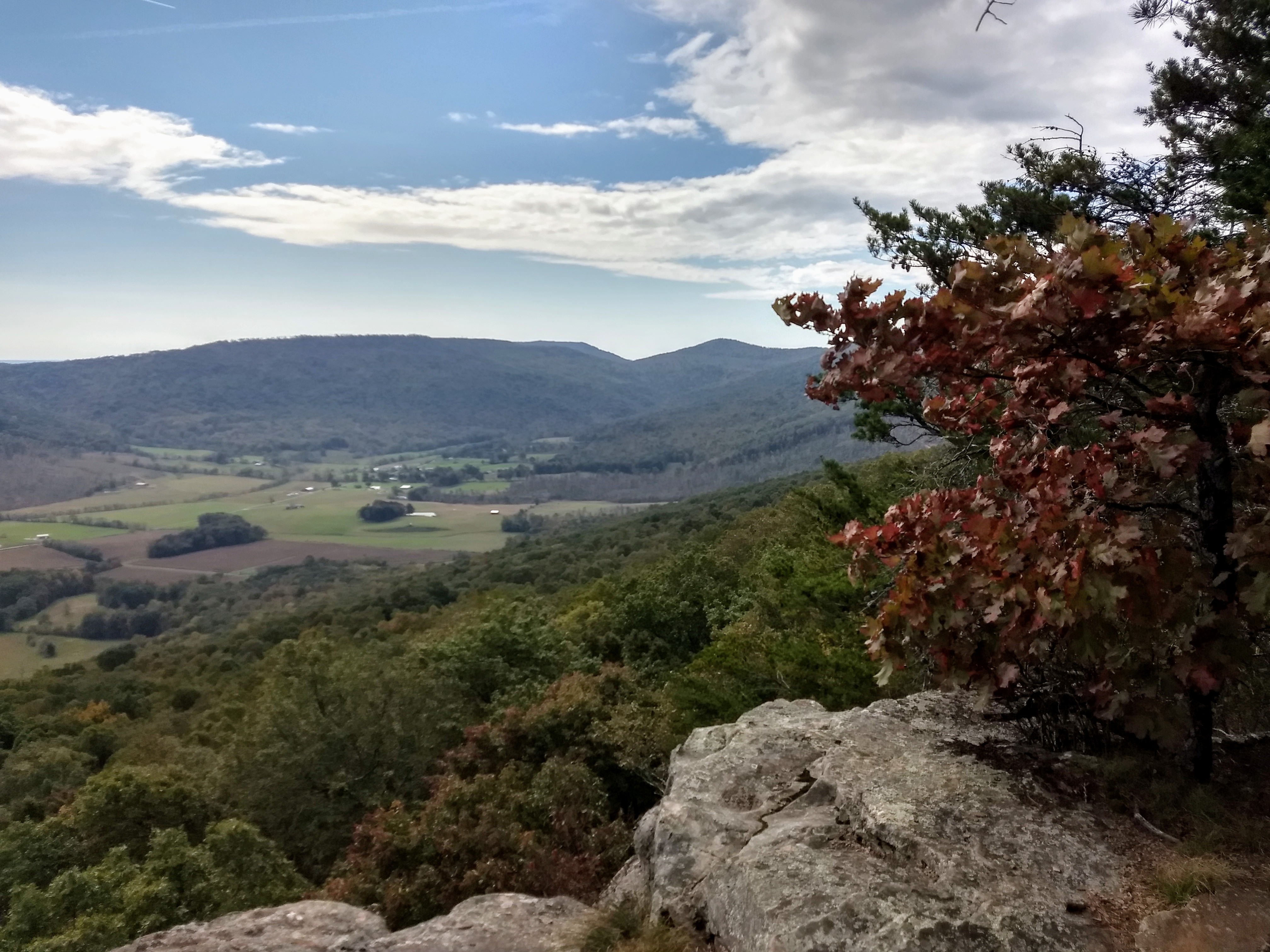 This is a view from the Cumberland Trail atop Brady Mountain. The complete trail, 50 years in the making, is almost done. Ben Pounds
The Cumberland Trail is nearly complete between Chatty and Cumberland Gap. That’s just the beginning.
Volunteers are putting the finishing touches on Tennessee’s Cumberland Trail, which will run from Signal Mountain near Chattanooga to Tristate Point near Cumberland Gap.
- cumberland trail
- completion
- cumberland plateau
- sequatchie valley
- hiking
- justin p wilson cumberland state park and state scenic trail
- great eastern trail
- tennessee state park
- cumberland trail conference
- tennessee trails association
- ozone falls
- crab orchard mountain
- lone star mountain
- piney river gorge
- hellican peak
At least $35 million headed to Smokies for southern Foothills Parkway overhauls and maintenance facilities improvements
Written by Thomas Fraser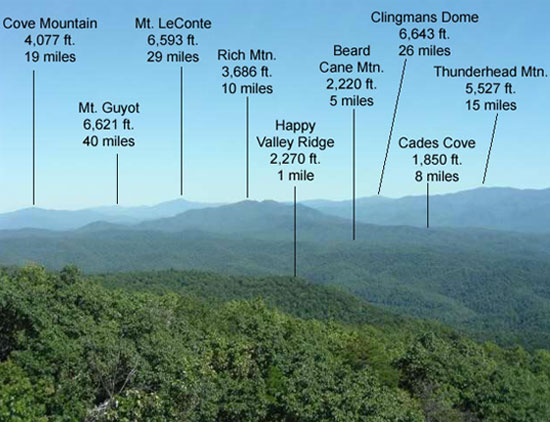 The crest of the Smokies and its peaks are shown from Look Rock on the Foothills Parkway. National Park Service
Southern stretch of Foothills Parkway to get $33 million overhaul
The National Park Service will repave and improve the entire southern stretch of Foothills Parkway and design a replacement of the outdated maintenance facilities at Sugarlands thanks to funding from the Great American Outdoors Act.
Both projects will cost a combined $40 million and be paid for via a foundation established as part of the overall legislation passed by Congress in 2020.
The Department of the Interior will spend a total of $1.6 billion from the Legacy Restoration Fund this year alone as part of a long-range goal to improve infrastructure and catch up on maintenance needs in national parks and other federally managed lands, according to a release. National public lands across the country, including Great Smoky Mountains National Park, have long faced maintenance deficits totaling billions of dollars.
The Foothills Parkway and Sugarlands work is one of 165 deferred maintenance projects that will be funded this year. Infrastructure improvements are also planned for sections of the Blue Ridge Parkway and Shenandoah National Park.
The $33.6 million in planned improvements to the parkway between Walland and Tallassee (from mile marker 55 to 72) will include enhanced safety features and milling and replacement of the pavement.
“The road rehabilitation will include pullouts and parking areas, replacing steel backed timber guardrail, and repair, reconstruction and repointing of stone masonry bridge parapet walls and the walls along Look Rock Overlook,” according to interior department documents.
“Other work will include removing and resetting stone curb, replacing/repairing of the drainage structures, stabilizing roadside ditches, overlaying or reconstructing paved waterways, stabilizing and reseeding the shoulder, installing pavement markings, replacing regulatory and NPS signs, and constructing ramps with curb cuts to provide access to interpretive panels and to meet federal accessibility guidelines.”
“The work proposed in this project would reduce the hazards and improve safety for park visitors and employees,” according to the data sheet.
The Legacy Restoration Fund will also cover the $3.5 million cost of a design/build plan to improve and update the expansive and deteriorating maintenance yard at Sugarlands.
“The buildings, driveways, and parking areas associated with the maintenance yard have not been renovated or rehabilitated in decades,” according to a data sheet.
“There are safety hazards, inadequate space or capacity for park maintenance and operations personnel, and facilities that are entirely insufficient for essential park operations and maintenance. The condition of many buildings is so poor that replacement and disposal is likely the only practical option. This project will complete predesign project programming and budgeting and develop a Design Build RFP for the rehabilitation or replacement of facilities and associated utilities, parking, and grounds.”
Great Smoky Mountains National Park officials did not immediately respond to an email requesting additional information on possible future projects and to what extent national infrastructure plans proposed by the Biden administration might benefit the park, which is the most-visited in the nation.
Here’s a link to the full Department of the Interior National Parks and Public Land Legacy Restoration Fund Fund release. Here are the Foothills Parkway and Sugarlands maintenance yard project data sheets.
The Appalachian Voice: Critter corridors aspire to provide Safe Passage for roaming mountain wildlife
Written by Frances Figart Bears stand by a roadside guardrail. Bridget Donaldson, Virginia Transportation Research Council
Safe Passage initiative calls for wildlife and human protections along mountain highways
Jean Loveday is driving her husband, Tom, home from a doctor’s appointment in Johnson City, Tennessee. Their Toyota pickup truck is winding along Interstate 26, not far from the North Carolina state line north of Asheville.
Suddenly Loveday sees something black tumbling down the mountain and out into the highway in her peripheral view. “Oh no, Tom, oh no!” she mumbles. Loveday realizes it’s a bear cub hurtling toward them. She attempts to avoid hitting it by steering into the median, but vehicle and animal seem destined to collide.
“It all happened so fast,” she says today. “I don’t know where its mother was, whether the cub was following her or on its own. We stopped. It moved for a few minutes, and then was still. All I could think for days was, ‘I killed a bear cub!’ I hope I never, ever have to go through that again.”
Loveday is overwhelmed with emotion as she relates this sad memory, one shared by many motorists in the Southern Appalachians.
“I don’t care where you are on the political spectrum, no one wants to hit an animal with their vehicle,” says Jeff Hunter, senior program manager for National Parks Conservation Association, an organization devoted to protecting and enhancing the national parks system for future generations.
“Human infrastructure is making it increasingly difficult for wildlife to follow their natural patterns of movement across the landscape,” says Hugh Irwin, a landscape conservation planner with The Wilderness Society who raised concerns back in the 1990s about I-40 being a barrier to wildlife movement. “Historically too little thought and planning has gone into wildlife needs, and our current infrastructure fails to provide for wildlife passage.”
Passionate discussions led to action, and soon more than 80 individuals from nearly 20 federal, state, Tribal, and non-governmental organizations were collaborating to make this section of roadway more permeable for wildlife and safer for people.
Roadkill’s “Pernicious Twin”
The intersection of roads and wildlife is a safety issue that is not unique to North Carolina and Tennessee. According to the Federal Highway Administration, an estimated two million large mammals are killed on roads in the United States each year, resulting in more than 26,000 human injuries and at least 200 human fatalities.
For years, road ecologists around the world have been working to mitigate highways that were originally designed without consideration for wildlife. Europe, Canada, Mexico, and many U.S. states have already created effective wildlife road crossings. Recent articles and videos featuring large wildlife overpasses in Utah and Texas have been shared widely on social media.
Senior Research Ecologist Marcel Huijser (pronounced ‘Houser’) with the Western Transportation Institute at Montana State University in Bozeman has contributed to road ecology studies for more than two decades. He cites three main reasons why people care about this issue: the desire for wildlife conservation, concern for human safety, and economics. “No matter who you are, where you live, or what you do for a living, you’re going to care about at least one of these,” he says.
On November 26, 2019, The Atlantic ran an auspicious road ecology article by Ben Goldfarb titled “How Roadkill Became an Environmental Disaster.” Focusing on the giant anteaters of Brazil, whose range is — you guessed it — bisected by a huge highway, the epic, riveting story introduces readers to Evelyn the anteater and a cast of road-weary researchers. One particular Goldfarb quote became the motto for researchers assessing wildlife movement and mortality in the Pigeon River Gorge: “Collisions may be road ecology’s most obvious concern, but fragmentation is roadkill’s pernicious twin.”
Conservationists point out the gravity of individual animals being killed on roads. But when they no longer try to cross, it can signal an even more dire situation.
“When wildlife finally stops even trying to cross, the highway has become a barrier,” says Hunter. “The ‘barrier effect’ is not to be confused with the concrete Jersey barriers that prevent many individual crossings. When a whole population stops crossing the road, that means their habitat is now fragmented, preventing the healthy genetic exchange that species need to thrive.”
Ron Sutherland works to restore, reconnect and re-establish wildlife corridors that have been fragmented throughout the eastern United States in his role as chief scientist with Wildlands Network, the organization that kicked off discussions about mitigation to I-40 in 2015. He defines habitat connectivity as the degree to which organisms are able to move freely across the landscape.
“Habitat connectivity can be very high, such as in a remote and intact wilderness,” he says, “or it can be very low, such as in a city park surrounded on all sides by busy highways.”
Sutherland points out that people often get wildlife corridors and wildlife road crossings confused.
“A wildlife corridor is the term we use for a defined movement pathway that, if protected or restored, would provide essential habitat connectivity for one or more species,” he says. “They can be easy to see — such as a vegetated trail alongside a roadway — or nearly invisible and defined only by the movements of the animals.”
A wildlife road crossing, on the other hand, is “a structure that is designed to allow wildlife to safely cross over or under a busy road,” he says. “So, of course it follows that one of the best places to put wildlife road crossings is where you have a wildlife corridor that gets cut off by a highway.”
Read the rest of the story at The Appalachian Voice.
Into the Royal Blue: Public and private lands crucial for cerulean warbler preservation
Written by Stephen Lyn Bales
Ephemeral birds of lasting beauty dependent on Tennessee forest
Think azure. A male cerulean warbler is sky blue. And to see one, you have to climb to the tops of certain Appalachian ridges and look toward the wild blue. To see one is to see a bit of heaven in an eight-gram bird.
East Tennessee’s Royal Blue Unit is not named in honor of the cerulean warbler but it’s appropriate to think so. The land parcel is part of the North Cumberland Wildlife Management Area and is one of the few places — very few places — the sky-blue passerines still nest in North America. It is estimated that 80 percent of the remaining population nests in the Appalachians.
The cerulean is the fastest declining migratory songbird in North America, said ornithologist David Aborn, an assistant professor of biology, geology and environmental science at UT Chattanooga. The Breeding Bird Survey estimates that cerulean warbler population declined by 70 percent between 1966 and 2008.
“The species is not in danger of imminent extinction, but is rare enough to warrant concern, and its future is not assured,” the U.S. Fish and Wildlife Service reported in 2020.
Currently a management goal of “no net loss” is in place. “Management programs can be instituted at the present time that do not require major changes in land-use practices, but do consider silviculture appropriate to producing habitat for the species,” the report concluded.
The American Bird Conservancy and ProAves Colombia purchased 500 acres of rural land identified as wintering sites for the migratory bird. The Cerulean Warbler Reserve is the first in Latin America set aside for a migrant bird. It’s a start. But the beautiful bird faces many challenges here and abroad.
Smokies bear vs. hog viral video: Yep. That’s about right.
Written by Thomas FraserSmokies biologist: Bear vs. hog video highlights nature taking its course

City to add new sidewalks and other measures to promote walkability on South Knoxville waterfront
Written by Thomas Fraser Suttree Landing is among the South Knoxville waterfront locations that will be connected via an ambitious city streetscaping project. Courtesy City of Knoxville
Walk it out: Knoxville plans $10m in streetscape, transportation improvements along Tennessee River in SoKno
The city announced March 24 it will soon embark on part of an ultimately $10 million project to improve walkability and pedestrian safety in the burgeoning South Knoxville waterfront community.
The improvements aim to better connect Sevier Avenue with the waterfront, and include sidewalk construction on main neighborhood streets, better lighting and curb and drainage work near Suttree Landing Park, according to a release from the city. It’s part of a long-term plan to install and improve sidewalks and bike lanes and generally make the area less dependent on automobiles. Aesthetic improvements such as the relocation of overhead utilities are also planned.
“Connectivity and walkability on and near the South Waterfront are important,” said city Deputy Chief of Economic and Community Development Rebekah Jane Justice. “Here on Waterfront Drive, a privately-developed apartment community is planned, but these public sidewalks and other upgrades will benefit the entire community. It’s a step in the right direction toward making it easier for pedestrians to get between Suttree Landing Park and Sevier Avenue,” Justice said in a press release.
“In the coming few years, the city will be investing $10 million in a streetscape overhaul of Sevier Avenue – relocating unsightly overhead utility lines and adding bike lanes, improved sidewalks, street lighting, on-street parking and a new roundabout at the Sevier Avenue, Island Home Avenue and Foggy Bottom Street intersection,” according to the release.
Here’s the rest of the announcement from the city:
“By the end of the year, new sidewalks will be constructed on sections of Waterfront Drive, Langford Avenue, Dixie Street and Empire Street – a $733,263 project that also will add new streetlights and drainage, curb and utility upgrades in the area near Suttree Landing Park on the South Waterfront.
Knoxville City Council last evening on March 23 authorized Mayor Indya Kincannon’s administration to execute an agreement with Design and Construction Services Inc., the company submitting the lowest, most responsive bid to do the Waterfront Drive Roadway Improvements Project.
Work on Claude and Barber streets in the vicinity will be undertaken as funding becomes available.
This type of project, Justice said, is a good example of the City investing strategically to advance one of Mayor Indya Kincannon’s core priorities – building healthy and connected neighborhoods.
One of those planned private investments is South Banks, an apartment community that Dominion Group hopes to construct by next year off Waterfront Drive.
Connecting the Sevier Avenue commercial corridor with Suttree Landing Park by improving public infrastructure between the two points is a short-term city objective. It’s the first of much more to come.”
The days the Earth stood still (Part 1): Covid cleared the air in the lonely Smokies
Written by Thomas Fraser Great Smoky Mountains National Park Air Resource Specialist is seen at the Look Rock air quality research station. Courtesy National Park Service
The lack of regional and local vehicle traffic during the pandemic greatly reduced measurable pollution in Great Smoky Mountains National Park.
This is your Hellbender weekend read, and the first in an occasional Hellbender Press series about the effects of the Covid-19 pandemic on the natural world
Great Smoky Mountains National Park shut down for six weeks in 2020 during the Covid-19 pandemic. Recorded emissions reductions during that period in part illustrate the role motor vehicles play in the park's vexing air-quality issues. The full cascade of effects from the pollution reductions are still being studied.
Hellbender Press interviewed park air quality specialist Jim Renfro about the marked reduction of carbon dioxide and other pollutants documented during the park closure during the pandemic, and the special scientific opportunities it presents. He responded to the following questions via email.
Hellbender Press: You cited “several hundred tons" in pollutant reductions during an interview with WBIR of Knoxville (in 2020). What types of air pollutants does this figure include?
- great smoky mountains national park
- coronavirus
- smokies
- pandemic
- air pollution
- covid19
- air quality
- shutdown
- pollutant reduction
- carbon dioxide
- co2
- motor vehicle
- jim renfro
- nox
- voc
- improvement
- haze
- ozone
- look rock
- emission
- greenhouse gas
- visitation
- visitor
- traffic volume
- analysis
- monitoring station
- particulate matter
- mercury
- acid deposition
- quality control
- quality assurance
- so2 regional haze rule
- national park service
- nps
- air resource specialist
- ecosystem
- bioaccumulation
- so2
- road closure
- power plant
- epa
- environmental protection agency
Being fire: Volunteers help preserve a classic East Tennessee cedar barren
Written by Thomas Fraser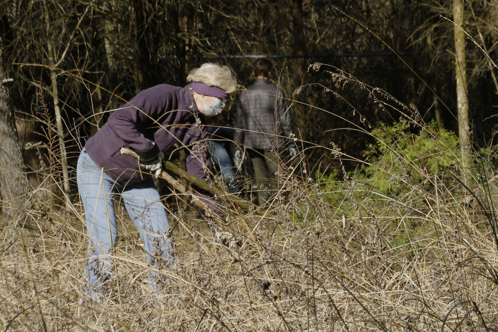 A volunteer removes invasive plants from an Oak Ridge cedar barren as part of a Tennessee Citizens for Wilderness Planning effort to keep the barren in its natural prarie state. Anna Lawrence/Hellbender Press
Volunteers play the part of fire to maintain the native grasses and wildflowers at an Oak Ridge cedar barren
OAK RIDGE — It’s called a barren, but it’s not barren at all. It’s actually a natural Tennessee prairie, full of intricate, interlocking natural parts, from rocks and soil to plants and insects and animals.
There’s lots of life in these small remaining unique collections of grasses and conifers that are typically known, semi-colloquially, as cedar barrens.
Many of these “barrens” have been buried beneath illegal dumping or asphalt, but remnants they are still tucked away here and there, including a small barren in Oak Ridge owned by the city and recognized by the state as a small natural area.
More...
Park service introduces permit system to protect Whiteoak Sink wildflowers
Written by Thomas Fraser A visitor to Whiteoak Sink in Great Smoky Mountains National Park photographs a wildflower. Courtesy National Park Service
Park managers hope new rule will limit trampling of the flowers people flock to photograph. Meanwhile, there’s sad news about the sink’s resident bats.
Large groups of spring visitors to the geologically and ecologically unique Whiteoak Sink area near Cades Cove will have to obtain permits in an ongoing effort to prevent damage to the sink’s plant and animal habitats.
The sink is home to vivid wildflower displays in the spring, and the 5,000 people who come to see the annual spectacle stray off trails and destroy or damage some plant species.
“The intent of the trial reservation system is to better protect sensitive wildflower species that can be damaged when large groups crowd around plants off-trail to take photos or closely view blooms,” according to a release from Great Smoky Mountains National Park.
Whiteoak Sink is off the Schoolhouse Gap Trail between Townsend and Cades Cove.
“This trial project will allow managers to determine if better coordinating group access can reduce trampling and soil compaction around sensitive plant populations.”
Update: Great Smoky Mountains National Park officials postpone controlled burn in Wears Cove to reduce wildfire fuel
Written by Thomas FraserPark service postpones 175-acre controlled burn
Citing low humidity and dry conditions, park officials postponed the planned burn until at least Tuesday along the park boundary in Wears Valley in the Metcalf Bottoms area. Another burn is planned near Sparks Lane in Cades Cove later in the week, depending on weather conditions.
Park managers plan a controlled burn along the park boundary in Wears Cove starting Monday. Don’t freak if you see heavy smoke in the area. March is an opportune time to conduct controlled burns for hazardous debris removal and habitat improvement in the interface between rural habitation and protected natural areas.
Fire prevention practices have become more widespread in Great Smoky Mountains National Park since a devastating and deadly November 2016 wildfire that spread into populated areas of Gatlinburg and Sevier County.
Here’s the straight skinny from the park service, per a release:
“Great Smoky Mountains National Park and the Appalachian-Piedmont-Coastal Zone fire management staff plan to conduct a 175-acre prescribed burn along the park boundary in Wears Valley to the Metcalf Bottoms Picnic Area. The burn will take place between Monday, March 8 through Thursday, March 11, depending on weather. Prescribed burn operations are expected to take two days.
A National Park Service (NPS) crew of wildland fire specialists will conduct the prescribed burn to reduce the amount of flammable brush along the park’s boundary with residential homes. This unit was burned successfully in 2009 and is part of a multi-year plan to reduce flammable materials along the park boundary with residential areas.
“A long-term goal of this project is to maintain fire and drought tolerant trees like oak and pine on upper slopes and ridges in the park,” said Fire Ecologist Rob Klein. “Open woodlands of oak and pine provide habitat for a diverse set of plants and animals, and the health of these sites benefits from frequent, low-intensity burning.”
New Jarvis Park in Maryville could total nearly 50 acres
Written by Thomas Fraser
Go check out the ancient oaks in Maryville’s new park
Jarvis Park is 1.5 miles southeast of downtown off South Court Street and includes nearly 10 acres owned by Maryville doctor Craig Jarvis that were protected under a conservation easement via Foothills Land Conservancy in 2018 and transferred to the city a year later.
Park highlights include two 250-year-old oak trees, a mile of walking trails and a creek near Duncan Spring.
An additional 37 acres, consisting of two lots adjacent to the park, will be transferred for preservation to the city in the future, per current expansion plans, according to a conservancy digital newsletter. That acreage would adjoin the park.
“Jarvis Park ... is one of the few remaining intact woodlands in the area,” according to the conservancy, which added it was “bordered by open farm fields, residential development, and a rock quarry operation.”
The park is one of 20 other such easements held by the conservancy that total more than 4,000 acres in the immediate Blount County area.
Reckoning with racism with a walk in the woods
Written by Thomas Fraser
Video documents success of ‘Smokies Hikes for Healing’ endeavor
Great Smoky Mountains National Park Superintendent Cassius Cash was as shaken as the rest of us this past spring and summer when a national reckoning of racism erupted across the country following the homicide of George Floyd under the knee of a Minneapolis police officer.
Also like many of us, Cash, who is Black, wondered what he could do to help heal 400-year-old wounds.
He determined we needed to take a walk in the woods and talk about things.
“As an African American man and son of a police officer, I found myself overwhelmed with the challenges we faced in 2020 and the endless news cycle that focused on racial unrest,” Cash said in a press release distributed Feb. 26.
“My medicine for dealing with this stress was a walk in the woods, and I felt called to share that experience with others. Following a summer hike in the park, I brought together our team to create an opportunity for people to come together for sharing, understanding, and healing.”
Sixty people directly participated in Cash’s Smokies Hikes for Healing program, Smokies Hikes for Healing, which ran from August to December in the national park. Hundreds of people visited an accompanying website to learn more or acquire information on how to lead their own such hikes.
Cash, who credited the park team who helped him organize the innovative project, correctly determined there was no more appropriate place to honestly discuss racism and the importance of diversity than a hike in one of the most biologically diverse places on the planet.
David Lamfrom, Stephanie Kyriazis and Marisol Jiménez, facilitated the hikes and created a “brave space for open conversations about diversity and racism,” according to the park release, which also announced the availability of the Smokies Hikes for Healing video produced by Great Smoky Mountains Association.
Friends of the Smokies and New Belgium Brewing Company also contributed financial support to the effort.