Sustainability (498)
Children categories

Sustainable Development Goals (912)
The Sustainable Development Goals are a universal call to action to end poverty, protect the planet and improve the lives and prospects of everyone, everywhere. The seventeen Sustaiable Development Goals (SDG) were adopted by all UN Member States in 2015, as part of the 2030 Agenda for Sustainable Development which set out a 15-year plan to achieve the Goals.
In war-torn Ukraine, nature refills reservoir destroyed by Russia
Written by Ruchi Kumar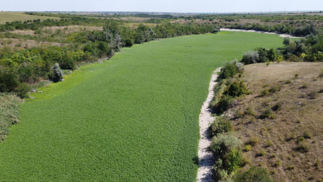 A range of vegetation has moved into the former Kakhovka reservoir in Ukraine. Russian occupying forces destroyed the dam along the Dnieper River in June 2023. Photos by Serhiiy Skoryk
Russia’s bombing of Kakhovka Dam in 2023 killed hundreds of people and tens of thousands of animals, but it also provided a potential ecological reset.
This story was originally published by The Revelator.
KYIV — In the early hours of June 6, 2023, two large explosions reverberated across cities and small towns located on the banks of the Dnieper River in southern Ukraine. The Russian military had reportedly set off multiple bombs, destroying the three-kilometer-long Kakhovka Dam and draining its massive reservoir into nearby settlements.
Water from the dam flooded the plains, killing hundreds of civilians and countless livestock, destroying farms, and displacing the residents of more than 37,000 homes.
The bombing made headlines around the world. It’s the long-term impact of the attack on the local biodiversity, however, that has scientists and experts concerned. In the weeks following the explosion, researchers from Ukrainian ministries and independent organizations carried out several assessments as best they could to the backdrop of the war.
They found that the attack had flooded about 60,000 hectares (230 square miles) of forest in at least four national parks, threatening an estimated population of 20,000 animals and 10,000 birds.
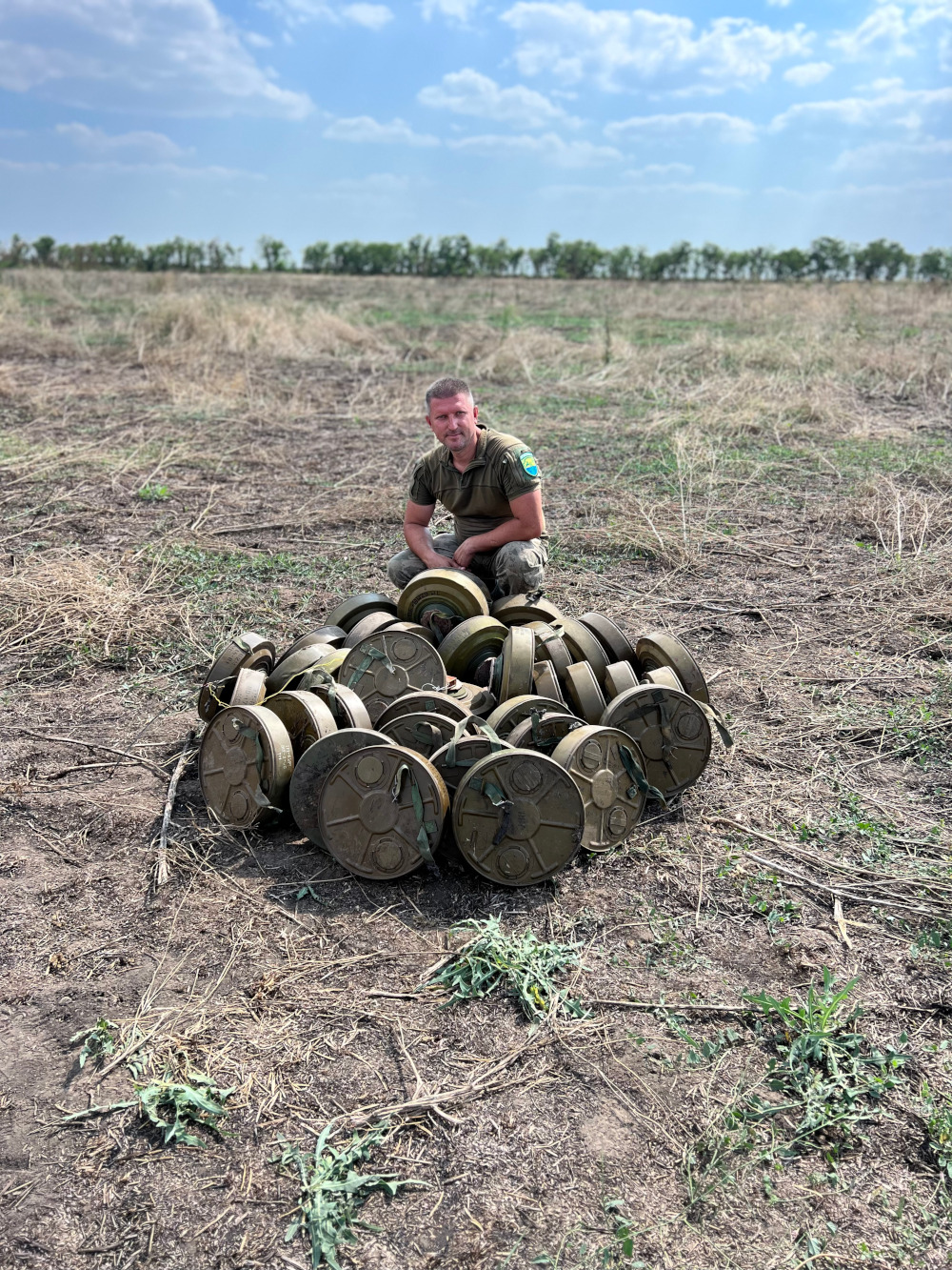 Serhiiy Skoryk, a national park director, is seen with landmines that are typical of those that have literally flooded the conflict zone during the Russian occupation of parts of Ukraine. These mines and other hazards complicate efforts to gauge the impact of the Russian invasion on Ukraine’s unique natural environment.
- russian ukraine conflict
- russian ukraine war
- ukraine war
- ukraine reservoir
- war and nature
- war effects on environment
- war pollution ukraine
- war affects on environment
- the revelator
- kakhovka dam
- dnieper river
- rewilding
- nature reclaiming reservoirs
- examples of nature reclaiming reservoirs
- legacy landmines
- landmine dangers
A long, sad tale of when coal ash filled a valley so low
Written by Ray Zimmerman In the early morning hours of Dec. 22, 2008, the earthen wall of a containment pond at Tennessee’s Kingston Fossil Plant gave way. The breach released 1.3 million cubic meters (1.7 cubic yards) of sludge, infiltrating a nearby river and damaging dozens of homes. NASA Earth Observatory
Journalist’s book offers deep sweep of 2008 coal-ash disaster at TVA’s Kingston coal plant
CHATTANOOGA — Jared Sullivan’s book, Valley So Low, is “A courtroom drama about the victims of one of the largest environmental disasters in US history — and the country lawyer who challenged the notion that, in America, justice can be bought.” Those words from the publisher’s dust jacket sum up the story, but the pathos of workers, certain that they got sick on the job, and the lawyer’s struggle against a well-funded corporate defense, is in the details.
Most residents of the Tennessee Valley remember the 2008 disaster when a wall of a coal ash slurry rushed out of the Kingston Steam Plant, flooding the Emory River and inundating 300 acres of the surrounding countryside.
Sullivan offered insight into the story to an audience in Chattanooga in October. When workers fell ill after the cleanup, local personal injury lawyer Jim Scott challenged Jacob’s Engineering, a private company the Tennessee Valley Authority contracted to manage the cleanup. Scott was the only lawyer willing to take their case, according to Sullivan.
- jared sullivan
- kingston coal ash spill
- kingston coal ash spill book
- 2008 coal ash disaster
- coal ash cleanup
- coal ash spill
- coal ash contamination
- coal fly ash slurry
- valley so low
- valley so low review
- ray zimmerman
- chattanooga nature events
- tennessee valley authority
- is coal ash storage unsafe
- coal ash book
- environmental journalist
- environmental journalism
Red-cockaded woodpecker gets new lease on wild life
Written by Georgia Department of Natural Resources A red-cockaded woodpecker in flight. The U.S. Fish and Wildlife Service announced last month the bird had been removed from the Endangered Species List. Martjan Lammertink/USFS
Staccato voice of Southern woodlands removed from Endangered Species List
ATLANTA — Life is looking up for red-cockaded woodpeckers.
These perky, family-focused woodpeckers of mature Southeastern pinelands — they’re the nation’s only woodpecker that excavates cavities in living pines — had been federally listed as endangered for 50 years. Yet late last month, the U.S. Fish and Wildlife Service downlisted them to threatened.
Their recovery from an estimated 1,470 family groups in the 1970s to about 7,800 groups today from Virginia to Texas reflects decades of work by government agencies, nonprofits and private landowners.
Georgia mirrors that outlook and effort. The number of red-cockaded woodpecker family groups here “is now well north of 1,500,” said Joe Burnam, lead Department of Natural Resources biologist for the species.
The success story ranges from military lands like Fort Stewart, where controlled burns and “recruitment” clusters of artificial nest cavities inserted in trees are helping the population grow, to southwest Georgia quail properties enrolled in Safe Harbor, part of a U.S.-first habitat conservation plan that DNR developed in 1999 for the woodpeckers and private landowners.
Burnam said the downlisting keeps federal protections in place and will not affect DNR conservation practices in the state. “We’ll continue to do what we’ve been doing … managing for the birds (and) their habitat.”
Habitat loss and degradation, a combo that landed the woodpeckers on the Endangered Species Act list, remain the leading threats. For example, Hurricane Helene wiped out over 40 percent of the nest cavity trees at Moody Forest Wildlife Management Area and Natural Area near Baxley.
But new cavity inserts have already been chainsawed into pines, and others will be added, Burnam said.
Helene: A month after epic flooding, Smokies still reeling from storm effects
Written by Holly Kays The Hiram Caldwell House looks out over a road rendered impassable following major flooding on Rough Fork Creek. Cataloochee Valley is closed until further notice. National Park Service
Damage to park infrastructure widespread on North Carolina side of Great Smoky Mountains National Park
Holly Kays is the lead writer for Smokies Life.
GATLINBURG — As Hurricane Helene gathered strength in the southern Gulf of Mexico, it seemed likely Great Smoky Mountains National Park would take a direct hit. The storm was a category 4 before slamming Florida’s Gulf Coast; then it headed north toward the Smokies.
But its course shifted east. Helene and its predecessor storm dropped unfathomable amounts of rain across Southern Appalachia — many places received well over a dozen inches in a matter of days, with some locations recording two dozen or more. The storm’s severity was unprecedented in the region, causing flash floods and landslides that have so far claimed at least 95 lives in North Carolina alone. Asheville, where extreme flooding destroyed entire neighborhoods and decimated the water system, logged more than 14 inches between September 24 and September 28.
Most of the park fell far enough west of Helene’s path to escape with only minor flooding, but its extreme eastern region — Cataloochee, Balsam Mountain, Big Creek — was inundated. Record-setting rains tore out trails and roads and damaged historic buildings, leading the park to close these areas until further notice.
 Cataloochee Valley is closed until further notice after flooding from Rough Creek Fork rendered Upper Cataloochee Valley Road impassable. National Park Service
Nukes hit Oak Ridge airport: Plans on hold in favor of private science enterprise
Written by Ben Pounds Illustrated photo from a presentation on the Oak Ridge Airport project to Roane County officials at the Roane County Courthouse in Kingston on Thursday, Dec. 7, 2017 soon after the state appropriated $15 million for use toward the now-paused airport project. Roane County via Oak Ridge Today
City: Airport ‘paused’ because of nearby planned uranium-enrichment facility
OAK RIDGE — The city paused its long-simmering and controversial project to build a general aviation airport in the western part of Oak Ridge.
Oak Ridge government announced it paused the plan to build the airport in part of East Tennessee Technology Park because another nearby project is going forward: Orano USA’s Project Ike. Orano announced its plans for that project, a large uranium enrichment facility, Wednesday, Sept. 4; the city of Oak Ridge announced its pause the following week, Wednesday Sept. 11.
The city stated it wanted to “re-evaluate the proposed location” for the airport due to the Orano plan. City communications specialist Lauren Gray declined to name any other locations the city might be considering, saying plans weren’t that definite yet.
(Hellbender Press won a first-place award from the East Tennessee Chapter of the Society of Professional Journalists for its previous coverage of the proposed Oak Ridge airport).
Helene: After frightful pause, nation’s historical weather data and its aggregators are safe at Asheville NOAA centers
Written by John Bateman NCEI’s Physical Archive in Asheville, N.C. contains historical environmental data on paper and film. The Physical Archive remains safe and secure following Hurricane Helene and catastrophic flooding in the Southern Appalachians. NOAA
Staff and data holdings safe; webpages, products and services in the process of coming back online
John Bateman is a public affairs officer with the National Oceanic and Atmospheric Administration.
ASHEVILLE — NOAA’s National Centers for Environmental Information (NCEI), headquartered in Asheville, is recovering from the impacts of Hurricane Helene. NCEI has confirmed that all of its employees and staff are safe, and is continuing to support them through the storm recovery. NCEI data holdings — including its paper and film records — are safe.
NCEI’s broadband internet provider is now fully operational. In addition to the recently reestablished connectivity, NCEI is leveraging facilities and staff in Colorado, Mississippi and Maryland to bring some system and data “ingest” capabilities back into operation. NCEI has resumed the majority of its data ingest streams and can confirm that data are being securely archived. We expect all ingest data pathways to be fully operational in the next two weeks.
NCEI continues to work with data providers to recoup data that were not ingested while systems were down. This work will take up to three months to be completed. NCEI will recover as much data as possible, however, some observations might eventually be unrecoverable.
 The CSX rail line through the Nolichucky River Gorge near Erwin, Tennessee was one of many transportation and vital commerce links destroyed by epic river flooding spawned by Tropical Storm Helene Sept. 26-27, 2024. Jonathan Mitchell for Hellbender Press
ORNL Climate Change Institute: Weirdly warm water that spawned and fed Hurricane Helene was 500 times more likely due to climate change
OAK RIDGE — Hellbender Press spoke with Oak Ridge National Laboratory Climate Change Science Institute Director Peter Thornton about whether Hurricane Helene and its subsequent and disastrous impact on the Southern Appalachians was made worse by climate change. Citing an increasing scientific ability to link climate change to specific weather events, he said in a very matter-of-fact manner that yes, Helene was fueled by the symptoms and consequences of global warming caused by human emissions of carbon and other pollutants.
Thornton cited a World Weather Attribution report as a main source for his data and commentary, and summarized its research on Helene for Hellbender Press. Here is the interview, edited for clarity and brevity:
“I am the director of the Climate Change ScienceInstitute at Oak Ridge National Laboratory. I am a corporate fellow researchstaff at the laboratory in the area of earth system modeling and coupled carbon-cycle climatefeedbacks at the global scale all the way down to local scales.”
HP: The effects of Hurricane Helene were worsened by preceding rain events, correct?
“The event as it played out along the sort of the eastern flankof the Southern Appalachians was influenced strongly by precipitation that came beforethe storm even made landfall. There was what’s referred to as a stalled cold front, which was sitting over that SouthernAppalachian region and the front, kind of a linear element, stretched from Atlanta up along the flankof the Southern Appalachians.
“There were river stages that were already approaching record levels in some areasof that region before the storm arrived. There was probably moisture being pulled in from theouter bands of the storm into that stalled cold front, which was making that precipitation eventslightly bigger than it would have been otherwise. But it was an independentsynoptic-scale meteorological event.
(That could be linked to increased moisture, a hallmark of climate change, on the fringes of the tropical system, but there’s no data on that yet).
 Peter Thornton, director of the Climate Change Science Institute at Oak Ridge National Laboratory, is shown here doing climate-research field work in 2015. ORNL
Give peace a chance: Townsend, at the edge of the wild, wants your voice for land-use planning process
Written by Élan Young The city of Townsend sits on the northwestern side of Great Smoky Mountains National Park. It is one of the key gateways to the national park, which is the most visited in the country. A land-use planning process is underway at the behest of citizens to preserve the rural and peaceful nature of the town and Tuckaleechee Cove.
Plan organizers set open house to help preserve the Peaceful Side of the Smokies
TOWNSEND — The last 10-year land use and transportation plan for this key gateway to Great Smoky Mountain National Park expired in 2020. Residents and other stakeholders linked to the most-visited national park in the country are concerned about Townsend’s growth and development patterns; city leaders decided to pursue a new plan with a vision, at least, that could be used to help guide city ordinances well into the future.
The Townsend Community Plan process launched in July and is now in its second phase. It was initiated by the planning and city commissions to help guide land use and other decisions while seeking to preserve Townsend’s unique character and its reputation as the “peaceful side of the Smokies.”
A Planning Commission steering committee established the nine-member Townsend Community Plan Advisory Committee (CPAC), comprising a mix of city officials and community volunteers who have diverse backgrounds. At CPAC’s recommendation, the city is now under contract with two consultants, the East Tennessee Development District and the SE Group, which are splitting the work of guiding the community engagement process.
Now, on the heels of the devastation from Hurricane Helene in river towns throughout the Southern Appalachians, the community can provide their visions for the future of this tourist town along Little River during the second phase of the timeline, which focuses on community engagement.
The consultants will host an open house on Friday, October 18, from 4:30-6:30 p.m. at Heritage Center Amphitheater. Residents, visitors, national park lovers and other stakeholders are invited to engage in hands-on planning activities to share their vision for Townsend and the greater Tuckaleechee Cove area.
Updated Oct. 12: Helene: Recovery grinds along in Smokies, multiple major watersheds; questions arise about fate of Pigeon River sediment pollutants; major disaster averted at Waterville
Written by T. Fraser, JJ Stambaugh, P. Penland and W. Naegeli Debris hangs from trees on the banks of the French Broad River near the main building of Hot Springs Resort and Spa. The river gauge at Hot Springs was offline during the main rain events immediately preceding the Sept. 27 floods but registered a peak just under 21 feet. The record stage is 22 feet, but that record will likely fall after review of provisional weather-gauge data by the National Weather Service. Thomas Fraser/Hellbender Press
Two weeks after epic floods, a far cry from normalcy; utility repairs continue; Del Rio still reels; Hot Springs limps; outpouring of help and mountain grit as battered communities take stock
This story will be updated.
The original story and updates continue below. We have been adding more images, videos, links, live or interactive graphs and specifics to our earlier reporting and updates.
GATLINBURG — Great Smoky Mountains National Park staff continue to assess the damage sustained by the country’s most-visited national park during Tropical Storm Helene. (The storm was at tropical storm strength when it struck the mountains Sept. 26-27, prompting a rare tropical-storm warning for Western North Carolina).
The Cataloochee and Big Creek areas on the North Carolina side in Haywood County were particularly hard-hit, and significant damage was reported to park cultural resources and road and bridge infrastructure. Those areas remain closed. Most roads and trails on the Tennessee side of the national park are open. Cataloochee is a valuable tourist draw during the fall rutting season of elk populations successfully reintroduced to the park in the 1990s.
 Tropical Storm Helene destroyed Upper Cataloochee Road in Great Smoky Mountains National Park and damaged other park infrastructure and historical resources. National Park Service
Here’s an update from the National Park Service:
“The park experienced substantial damage, particularly in North Carolina, including Balsam Mountain, Big Creek and Cataloochee Valley.
Updated Oct. 2: Helene hits the mountains: Death toll nears 200; factory scrutinized after worker deaths in Erwin; major roads and railroad links still cut; massive recovery underway; havoc in So. Appalachians
Written by T. Fraser, JJ Stambaugh; P. Penland and W. Naegeli
Helene fallout continues; hundreds still missing; at least 60 dead in NC; flooding and wind damage still widespread in Southern Appalachians; National Guard in action; land access, supplies, communications, water and power still spotty
This story will be updated.
The original story and updates continue below.
We have been adding more images, videos, links, live or interactive graphs and specifics to earlier updates, too. So, keep scrolling to glean them after touching the More… button. You may want to bookmark some of the interactive features for your own present and future use.
 Demolished vehicles are seen in the area of what used to be Red Banks Campground in the Chestoa area of Unicoi County. Thomas Fraser/Hellbender Press
ERWIN — The death toll from Hurricane Helene climbed to at least 180 people on Wednesday, making it the deadliest hurricane to hit the United States in 50 years with the exception of Hurricane Katrina, which claimed over 1,800 lives in 2005 in what was also a largely impoverished area.
In one-hard hit community in the mountains of northeast Tennessee, emotions grew high as Spanish-speaking family of missing loved ones accused first responders through an interpreter of showboating, classism and preferential rescues during a tense press conference broadcast live on X.
The mounting death toll and increasingly fruitless searches came as millions of people spent their sixth day without running water or power and an ad hoc army of first responders, volunteers and National Guard troops struggled to deliver life-saving supplies to communities throughout the Southern Appalachians that were cut off by the record breaking flash floods spawned by the storm.
In Erwin, a town of 6,000 in Unicoi County, officials confirmed that a criminal investigation had been launched into the conduct of a manufacturing company that was accused of forcing employees to keep working even as floodwaters rose to dangerous levels.
More...
TennGreen protects unique stream habitat amid population boom
Written by TennGreen Land Conservancy![springcreek]() Preservation of the Spring Creek watershed near Cedars of Lebanon State Park will protect water resources in a rapidly growing part of the Southeast. TennGreen Land ConservancyTennessee cave salamanders, other wildlife will benefit from creation of unique preserve
Preservation of the Spring Creek watershed near Cedars of Lebanon State Park will protect water resources in a rapidly growing part of the Southeast. TennGreen Land ConservancyTennessee cave salamanders, other wildlife will benefit from creation of unique preserve

LEBANON — TennGreen Land Conservancy joined with Headwaters Reserve LLC to protect and restore a high-risk stream habitat adjacent to Cedars of Lebanon State Park. Located on approximately 47 acres, the property’s streams and wetlands are protected by a conservation easement held by TennGreen in perpetuity.
The waters of this property, called Cedar Forest, are within the Spring Creek watershed, which has been noted to contain more than 28 rare species, including the Tennessee cave salamander (Gyrinophilus palleucus).
Stream restoration, a vital process that breathes new life into natural aquatic environments, is a key objective of this conservation easement, offering numerous benefits to both wildlife and the community.
This permanent protection and intentional restoration will help to remove pollutants from waters in one of the nation’s fastest-growing counties while protecting the resource for generations to come.
TennGreen has previously conserved land in the area to expand Cedars of Lebanon State Park and Natural Area and Cedars of Lebanon State Forest.
Nov. 2: Celebrate fish at the bird park — Sturgeonfest 2024

This event was rescheduled from its original date.
KODAK — Take a break from football, grab the kayaks, get outside and join your friends and family for Sturgeonfest 2024 on the French Broad River!
The FREE celebration of the ancient fish, their lore and their future is set for 10 a.m. to 2 p.m. Nov. 2 at Seven Islands State Birding Park boat ramp.
-
Release a baby sturgeon into the French Broad River!
-
Enjoy food from Kennedy Grill Food Truck, Crave Food Truck, Giddy Up Coffee Truck, Central Creamery, and the King of Pops!
-
Enjoy music by the Tennessee Stifflegs!
To put a fish in the water, reserve a FREE ticket for everyone in your party for a specific time slot.
State your case in local quest to reduce greenhouse gas emissions
KNOXVILLE — The Knoxville Regional Transportation Planning Organization seeks the public’s feedback on greenhouse gas emissions in East Tennessee. Take this brief survey and make your voice heard:
- The survey takes about 10 minutes to complete and covers topics like climate change, energy efficiency and transportation to shape ongoing efforts to reduce greenhouse gas emissions in the region. The survey is open through Sept. 30 at www.knoxbreathesurvey.com
- Residents of all nine counties within the Knoxville Metropolitan Statistical Area (MSA) — Knox, Anderson, Blount, Campbell, Grainger, Loudon, Morgan, Roane and Union — are encouraged to take the survey and make their voices heard.
- The Knoxville MSA was one of 82 metropolitan areas in the U.S. selected by the Environmental Protection Agency (EPA) to receive a planning grant to create a regional emission reduction plan as part of the agency’s Climate Pollution Reduction Grants (CPRG) program. “BREATHE” is the name for the Knoxville region’s CPRG initiative.
- More information on “BREATHE” can be found at knoxbreathe.org
CANCELED Rural Resources 2024 Incredible Farm Dinner Downtown
 The annual Incredible Farm Dinner Downtown is a Greeneville tradition celebrating local farms and community. Hosted by Rural Resources Farm & Food Education Center, many local sponsors, business, farms, churches and the Town of Greeneville make this grand event possible. This dinner sells out every year — a testament to its success and the value of the Rural Resources programming it supports. Rural Resources
With the devastation across Greene County, we have decided to cancel this evening’s Incredible Farm Dinner Downtown.
Thanks to your support, we will donate the meals to those displaced, as well as first responders.
Please join us in praying for Greene County as we all help each other get through this difficult time.
Our Sincerest thanks for your continued support of the Rural Resources Farm Education Center.
Warmest Regards,
The Rural Resources Staff & Board of Directors
GREENEVILLE — This year the superlative annual fundraiser for the Farm & Food Education Center of Rural Resources will benefit Rural Resources’ Teen Training Program. The event will start at 6 p.m. on Saturday Sept. 28 at 615 West Main St. and feature Chef Elise Clair. She is creating a colorful seasonal menu sourced by our Greene County and East Tennessee neighbors.
Hailing from Richmond, Virginia, and a graduate of East Tennessee State University, Clair has a solid 25 years of experience in the culinary industry and scratch kitchens. Now with 15 years as vice president of JDD Enterprises, Clair maintains operations for The Main Street Pizza Company locations in Johnson City and Kingsport, River Creek Farm based in Limestone, River Creek Catering, and County Line Pie in Chuckey.
Claire focuses her menus and garden on seasonal Appalachian standards, highlighting local products from other Central Appalachian region growers and producers. On the farm, Clair and her partner maintain a non-certified organic practice fruit and veggie garden across multiple acres.
We invite you to desire, smell, taste and experience the quality of the freshly harvested meal prepared for you at The Rural Resources Incredible Farm Dinner. Hurry to secure your seats at the table!